HARMONY: Harmonized AI for Remote Monitoring of Soil and Land Dynamics 

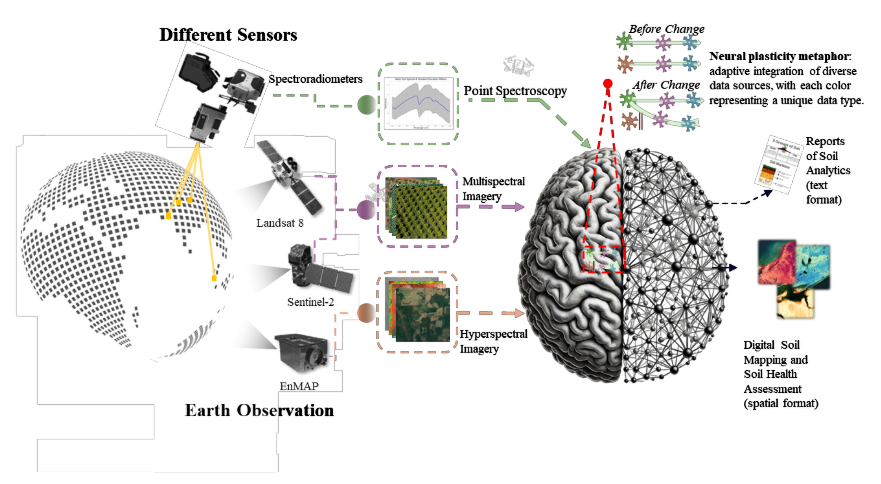
HARMONY is research project that aims to transform how soil health and land dynamics are monitored at regional to global scales. The project develops advanced artificial intelligence (AI) foundation models that harmonize diverse Earth Observation data sources, ranging from laboratory soil spectroscopy to multispectral and hyperspectral satellite imagery. By addressing data fragmentation across sensors, resolutions, and wavelengths, HARMONY enables consistent, scalable, and transferable soil analytics that support sustainable agriculture, climate resilience, and land management decision-making.

Technical approach

The project uses self-supervised foundation models inspired by neural plasticity to harmonize data from different satellite sensors and spectral resolutions. Masked autoencoding and sensor-adaptive layers allow the models to handle missing data and align observations from platforms such as Sentinel-2, Landsat, and hyperspectral sensors. Models are trained and validated using large georeferenced soil datasets and implemented through scalable data-cube infrastructures.

Expected outcomes

HARMONY will deliver high-resolution, spatial maps of key soil properties such as soil organic carbon, pH, and cation exchange capacity across diverse landscapes. The project will produce robust AI models that generalize across regions and sensors, outperforming traditional soil mapping approaches.

Impact

The project delivers a unified framework that makes soil and land information comparable across different satellite systems and geographic regions. This reduces data fragmentation and enables scalable, repeatable soil monitoring beyond sensor- or location-specific models.

Outreach materials