
FLSoilHealth: Decadal Changes In Carbon And Dynamic Soil Properties In Florida
This project aims to develop a transformative framework for monitoring and predicting changes in dynamic soil properties (DSPs) on a decadal scale, using Florida as a model system. Recognizing that traditional space-for-time substitution methods fail to account for complex spatial-temporal patterns under climate change, the research integrates historical soil survey data with new sampling campaigns to build a comprehensive decadal database. By leveraging advanced mid-infrared (MIR) spectroscopy and a novel artificial intelligence workflow, the study will characterize soil carbon sequestration and other critical DSPs across the state. The ultimate goal is to provide high-resolution predictive tools and maps that inform sustainable land management and water resource conservation in the face of stressors like warming, sea-level rise, and land-use shifts.
Technical approach
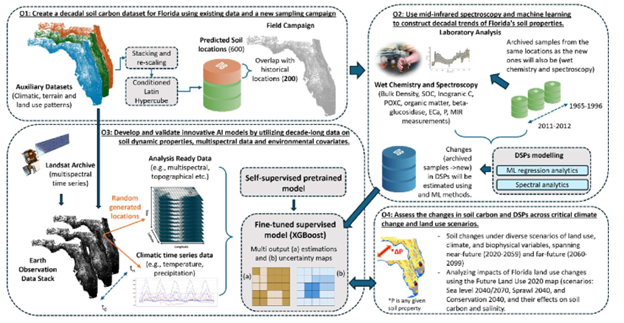
The technical approach utilizes a multi-phased methodology beginning with a data-driven field sampling campaign using the Conditional Latin Hypercube (cLHS) strategy to ensure a statistically representative selection of 600 locations across Florida. Laboratory analysis will involve elemental analysis for soil carbon and MIR spectroscopy to quantify a suite of DSPs, including active carbon and particulate organic matter. These data will feed into a novel hybrid AI workflow that employs self-supervised pretraining on large unlabeled datasets followed by supervised fine-tuning using XGBoost for multi-output regression. This workflow integrates multispectral satellite imagery, topographic variables, and PRISM climate data to model soil property changes. Finally, the project will utilize CMIP6 multi-model hydro-climate projections and future land-use maps to simulate soil responses under various socioeconomic and environmental scenarios.
Expected outcomes
- A comprehensive decadal database of soil carbon and dynamic soil property (DSP) changes in Florida, constructed by integrating new field samples with historical soil survey data.
- Validated predictive models and workflows that utilize mid-infrared (MIR) spectroscopy to accurately estimate changes in biologically labile carbon pools and other soil health indicators.
- A novel, hybrid artificial intelligence workflow capable of modeling and predicting soil property changes at high spatial and temporal scales across diverse landscapes.
- High-resolution (100-meter) digital soil change maps and a modular Soil-Environmental Data Cube that provides analysis-ready data for researchers and land managers.
- Detailed projections and assessments of soil carbon sequestration and salinity under various future climate change and land-use scenarios through the years 2070 and 2099.
- A transferable technical protocol, including step-by-step procedures and associated code, to allow the NRCS to upscale this soil change modeling approach to other regions.
Impact
By providing a high-resolution understanding of how soil properties evolve over decades, this project will significantly enhance the ability of land managers and policymakers to develop effective climate mitigation and adaptation strategies. The integration of AI and remote sensing into soil science offers a more accurate alternative to traditional mapping, allowing for the identification of soils most vulnerable to seawater intrusion and degradation. Furthermore, the project supports the professional development of graduate students and strengthens the collaboration between the University of Florida and the NRCS Soil and Plant Science Division. Ultimately, the insights gained will safeguard critical ecosystem services such as nutrient cycling and carbon sequestration, ensuring the long-term resilience of Florida’s natural and managed landscapes.
Outreach materials
Decadal Soil Changes: UF/IFAS study aligns with World Soil Day 2024 – Soil, Water, and Ecosystem Sciences